

A sustainable home’s viability is shaped by the site before the design begins. A parcel can look ideal and still have conditions that change the build or make it impractical. Evaluating land for a sustainable home build means looking beyond views and orientation to check soil, slope, drainage, hazards, access rights, utility connections and local approval requirements. It’s reasonable to want clear answers before committing capital, especially when site conditions aren’t visible from the road.
This guide explains how to identify material constraints before proceeding. You’ll learn what to review on the land, how to check servicing and access, and which environmental or approval questions to raise with qualified professionals and local authorities. It also explains why features such as on-site water systems, renewable energy and passive design must be assessed against the property rather than assumed to fit. Use your findings to document a decision: proceed, investigate further, redesign or decline. A disciplined site assessment is not a formality. It is the first test of whether the home you intend to build can work on that land.
Key Takeaways
- Start with the home you intend to build, then assess whether the parcel’s terrain, water conditions and ecology can support it.
- Use maps and listing details to identify questions, not as substitutes for site investigations by qualified professionals.
- Verify utility availability, servicing options and legal access rather than relying on proximity or assumptions.
- When evaluating land for a sustainable home build, compare parcels against the same intended use and evidence standard.
- Record what is confirmed, what needs expert review and whether unresolved constraints call for further investigation, redesign or declining the parcel.
Why evaluating land for a sustainable home build starts before design
A parcel isn’t feasible simply because it looks peaceful, has open space or receives good sunlight. Land evaluation checks whether a property’s physical conditions, access, servicing options and approval pathways can support an intended home. It is a feasibility assessment, not a finished design. The aim is to establish what the site can support before plans and spending depend on assumptions.
Land-use planning provides broader context for assessing land against environmental and community goals. This systematic assessment of land is one reason to consider a parcel in relation to its setting and applicable planning controls, not just its appearance. In Canada, requirements and approval pathways vary by jurisdiction, so confirm site-specific questions with the relevant authorities and qualified professionals.
What does land suitability mean for a sustainable home?
Suitability depends on the intended use. A site might appear buildable but still need further investigation into slope, drainage, soil, groundwater, vegetation, access or potential utility connections. Approval pathways matter too: assess the proposed home and its supporting systems against the requirements that apply to that property.
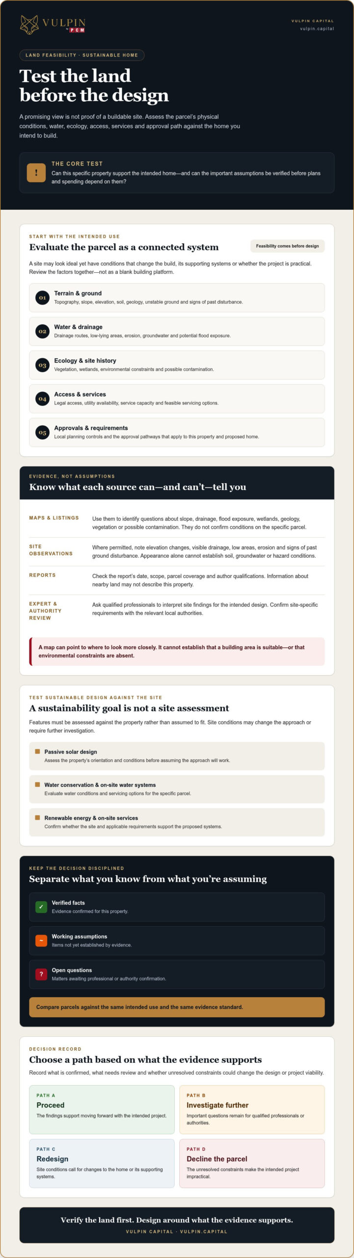
Test sustainability goals against the site conditions. A plan for passive solar design, water conservation or on-site services may need to change if the property’s orientation, water conditions or servicing options don’t support it. Keep a clear record of verified facts, working assumptions and questions awaiting professional or authority confirmation. A map or listing can help identify questions, but it can’t establish every site condition.
Why attractive land can still carry project risk
Physical constraints have practical consequences. A steep slope may affect where a home can sit. Drainage patterns can influence the site layout and require further assessment. Difficult physical access or limited service availability may change the build approach. These conditions don’t automatically mean a property should be rejected. They do mean you should verify what is possible before treating the parcel as ready for construction.
Interest in a property is not evidence. A compelling view or a seller’s description can’t confirm soil conditions, legal access, service capacity or approval requirements. Document the gaps, identify who can verify them and consider whether the answers could change the design or the project’s viability. Site conditions can also affect sustainable-build assumptions. See net-zero home construction costs in Canada for related context. The principle is simple: verify the land first, then develop a design around what the evidence supports.
How to assess the land, water, and ecology before choosing a design
Review the parcel as a connected system, not a blank building platform. Start with topography and note where the land rises, falls or collects water. Then consider drainage patterns, soil, groundwater, vegetation and signs of existing disturbance. These features can affect where a home may fit and which questions need professional review.
Mapped information about slope, drainage, flood exposure, wetlands, geology, vegetation or possible contamination is preliminary until confirmed for the specific parcel through appropriate site investigation and qualified review. Maps can show where to look more closely. On their own, they don’t establish that a proposed building area is suitable or that environmental constraints are absent.
Which physical site conditions can constrain a home build?
During a site visit, where permitted, note changes in elevation, visible drainage routes, low-lying areas, erosion and evidence of past ground disturbance. Ask what is known about soil and groundwater, and whether these conditions may affect foundation planning or the placement of site systems. Flood exposure, unstable ground or suspected contamination require site-specific verification, not conclusions based on appearance.
Review available reports for their date, scope, parcel coverage and author qualifications. A report about nearby land may not describe this property. There is no universal slope or soil threshold that determines suitability for every home. Ask qualified engineering professionals to interpret findings in relation to the intended design and identify any further investigation needed.
How do water and ecological features affect sustainable design?
Look for streams, wetlands, drainage features, significant vegetation and areas altered by past use. Their locations may influence where a home, access route or other site work can go. Don’t assume a feature shown on a map has been accurately bounded on the ground, or that an unmarked area has no constraints. Confirm applicable environmental requirements with relevant Canadian authorities and qualified advisers before settling on a site layout.
Consider how the design can work with the property. Check solar access and prevailing exposure, and assess whether existing vegetation could provide shelter or shade. These observations can inform design choices, but they don’t replace technical assessment or confirmation of applicable requirements.
When evaluating land for a sustainable home build, document each observation with its source, date and limitations. Separate what you’ve seen from what a map suggests and what still needs confirmation. Once site conditions and evidence gaps are recorded, a governance and verification process can help organize the next decision. Learn about The VULPIN Check for real asset deployment.
Can the parcel support services, access, and approvals?
Nearby infrastructure doesn’t prove a connection is available. When evaluating land for a sustainable home build, distinguish confirmed service availability from proximity, listing language and verbal assurances. Ask each relevant provider what options apply to the specific parcel, what connection requirements must be met and which details remain unconfirmed.
What should you verify about utilities and site access?
Check electricity, water, wastewater and communications separately. If municipal services aren’t available, ask the relevant authorities and qualified professionals whether alternative servicing approaches may be considered for the property and what site-specific review they would require. Treat a potential solution as unconfirmed until the appropriate parties have assessed it.
Access has both a legal and a physical dimension. Review title and other relevant records with appropriate legal or surveying professionals to establish whether access rights are documented. Then assess the route itself. A route may exist but still raise questions about its condition, location or suitability for construction activity. Record the evidence and any unresolved issue for each check.
How do zoning and approvals shape what you can build?
Contact the local planning authority to ask about permitted use and parcel-specific requirements. Describe the intended home and proposed site systems clearly. The authority can indicate which application process or further review may be relevant, while qualified advisers can help identify technical studies that may be needed. Requirements and processes vary across Canada, so don’t apply one municipality’s rules or timelines to another jurisdiction.
Ask for applicable requirements and guidance in writing where possible. Keep the authority’s response with the parcel records, noting what it confirms and what remains subject to formal review. Preliminary discussions can clarify next steps, but they aren’t an approval or a guarantee of an outcome.
Use a verification table to distinguish evidence from assumptions:
| Evidence found | Verification source | Outstanding question | Decision impact |
|---|---|---|---|
| Service line appears near the property | Relevant service provider | Can this parcel connect, and what requirements apply? | May affect the servicing approach |
| A route is shown or described as access | Title records and appropriate legal or surveying professionals | Are access rights documented, and is the route suitable for the intended use? | May affect legal or practical site access |
| Listing describes residential potential | Local planning authority | Is the intended use permitted, and what further review may apply? | May require investigation or a revised concept |
For each item, record what is confirmed, what is only proposed and who must resolve the gap. If an answer could change the servicing approach, access plan or approval pathway, make it a decision gate before committing further resources.
How to compare parcels without letting sustainability claims obscure risk
Compare every parcel against the same home brief and evidence standard. Claims such as “eco-friendly” or “ideal for off-grid living” don’t establish that a property can support your intended design. When evaluating land for a sustainable home build, separate marketing language from verified conditions. Make uncertainty visible instead of hiding it in a single score.
Use the same sequence for every property:
- Define the home brief: Record the intended use, key design goals and essential service needs.
- Collect records: Gather available parcel, access, servicing, environmental and planning information.
- Inspect constraints: Note how documented conditions may affect siting, systems or design choices.
- Verify gaps: Assign each unanswered question to the relevant professional, service provider or authority.
- Compare evidence: Assess what is confirmed, what remains uncertain and how each issue could affect feasibility.
Which evidence belongs in a parcel comparison?
For every document or professional opinion, record its source, date, relevance to the parcel and limitations. A report may be out of date, cover only part of the property or have been prepared for a different purpose. Note those limits plainly. Compare access, potential servicing, environmental constraints, approval questions and design implications on equal terms.
Separate findings into four categories: confirmed conditions, reasonable assumptions, unresolved questions and potential deal-breakers. Don’t give a parcel a favourable rating simply because evidence is missing. A documented risk register helps track each issue, the verification step and the possible effect. For a related method, see this construction project risk management framework.
How should sustainability goals influence the comparison?
Test each goal against the parcel. Compare orientation and solar access, the feasibility of the proposed water strategy, and whether material or energy choices fit the site’s physical and servicing conditions. One property may offer useful solar exposure but leave questions about water or access unresolved. Another may support some goals while constraining others. Neither should be judged by a broad environmental label alone.
Record the trade-offs, evidence and decisions needed for each property. This creates a defensible comparison, not a promise that every sustainability target can be achieved. To explore VULPIN Capital’s governance and verification approach for real asset deployment, review The VULPIN Check.
When to proceed, investigate further, or decline the land
A sound decision isn’t a verdict based on how attractive a parcel looks. It is a documented judgment about the evidence, the remaining unknowns and the consequences if those unknowns resolve unfavourably. When evaluating land for a sustainable home build, choose among three outcomes: proceed when material feasibility questions are resolved; investigate further when a missing answer could change the decision; or decline when a verified constraint conflicts with the intended use or acceptable design changes.
What belongs in a responsible go, pause, or no-go decision?
Before deciding, assemble a concise record of confirmed findings, open questions, required specialist input and potential effects on the home concept. For each unresolved item, identify who can verify it, what evidence is needed and which decision depends on the answer. A missing report isn’t proof of a problem, but it isn’t proof of suitability either.
- Proceed: Key site, servicing, access and approval questions have adequate evidence, and any remaining conditions are understood and acceptable.
- Investigate further: A material fact remains unknown, but qualified review could establish whether it can be addressed. Seek specialist input and, where relevant, legal advice about documenting conditions before making a commitment.
- Redesign or decline: Verified constraints require changes beyond what the project can accept, or the intended use can’t be supported on acceptable terms.
Keep the decision and its rationale in writing. Redesigning, investigating further and walking away are all legitimate outcomes. Don’t replace them with optimism about what a future approval or study might say.
How can governance carry site findings into project execution?
Once a parcel passes its decision gates, carry verified constraints into the design brief, scope and project controls. State assumptions clearly. For example, distinguish confirmed servicing from a connection that remains subject to provider review, and record any design choice that depends on further technical advice. Revisit assumptions when new evidence arrives. Don’t let an early estimate or concept drawing become an untested commitment.
PCMNow Project Management supports complex construction execution. Its role comes after site findings have been translated into documented scope and controls, not in place of parcel-level verification.
The VULPIN Check is a governance and verification process for real asset deployment. It provides a framework for disciplined consideration of evidence. It doesn’t guarantee approvals, costs, timelines or outcomes. After completing the decision framework, explore The VULPIN Check. For the next stage, review the construction project governance framework.
Carry verified site findings into the next decision
A sound land decision rests on evidence, not optimism. Evaluating land for a sustainable home build means understanding what the parcel can support, identifying what still needs confirmation and deciding whether the remaining uncertainty is acceptable. Proceed, investigate further, redesign or decline based on documented findings. Pausing for qualified review is a disciplined choice, not a setback.
Carry those findings into the project. FoxyHome provides environmentally conscious sustainable housing solutions, while PCMNow Project Management supports disciplined execution of complex construction projects. The VULPIN Check is a governance and verification process for real asset deployment. It supports structured assessment, but doesn’t guarantee approvals or project outcomes.
To consider how verification can inform your next decision, review The VULPIN Check. With clear evidence and a deliberate process, you can move toward a sustainable home project with greater confidence in the ground beneath it.
Frequently Asked Questions
What should I check before buying land for a sustainable home?
Check whether the parcel can support your intended home, services and approval pathway before committing. Review topography, drainage, soil, groundwater, vegetation, environmental constraints, legal and physical access, utility options and local planning requirements. When evaluating land for a sustainable home build, separate confirmed facts from listing claims and assumptions. Ask qualified professionals and relevant authorities to investigate material unknowns, and record how each answer could affect your design or decision.
Can you build a sustainable home on any parcel of land?
No. A parcel’s physical conditions, access, servicing options and applicable planning requirements can limit what may be built. Some sustainability goals may fit the site while others require changes. For example, orientation may support passive solar design, while water conditions or limited service options may affect the proposed water strategy. Confirm feasibility for the specific parcel with qualified professionals and local authorities. Don’t treat an environmental label or attractive setting as proof of buildability.
How do I know if land has access to utilities?
Ask each relevant provider to confirm service availability and connection requirements for the specific property. Check electricity, water, wastewater and communications separately. A nearby line or service doesn’t establish that the parcel can connect or clarify what work may be required. If municipal services aren’t available, ask qualified professionals and authorities what alternative servicing approaches may be considered. Keep provider responses and unanswered questions in your parcel records.
What happens if a property has wetlands or other environmental constraints?
First, confirm the feature’s location and extent on the parcel through appropriate site-specific investigation. A desktop map can flag a wetland, flood exposure or another potential constraint, but it may not establish precise boundaries or applicable requirements. Ask relevant authorities and qualified environmental advisers what rules, studies or approvals may apply before fixing a building area. The findings may affect site layout, disturbance plans, design feasibility or whether the parcel remains suitable.
Do I need a soil test before building a sustainable home?
Don’t assume soil is suitable based on surface appearance or information about neighbouring properties. Ask a qualified geotechnical or engineering professional what investigation is appropriate for the parcel and intended home. Soil conditions can inform foundation design and raise questions about drainage, groundwater or ground stability. Review any existing report for its date, scope, parcel coverage and author. The appropriate investigation depends on site conditions and project requirements.
How can I compare two parcels for a sustainable home build?
Use the same intended home brief and evidence standard for both parcels. Compare access, potential utility connections, servicing, environmental constraints, approval questions and design implications. For each finding, record its source, date, relevance to the parcel and limitations. Separate confirmed conditions from assumptions and unresolved questions instead of blending them into one score. This makes it easier to see which property has fewer material unknowns, not just stronger listing language.
When should I walk away from land for a home build?
Consider declining the parcel when verified constraints conflict with your intended use, required approvals can’t be established, or design changes exceed what you can accept. A missing answer alone doesn’t prove the land is unsuitable. It may justify further investigation before deciding. Set a clear process for resolving material unknowns, including specialist review and written conditions where appropriate. If the evidence remains inadequate or the remaining risks are unacceptable, walking away is a sound decision.